Fájl:Maurya Empire, c.250 BCE 2.png

Eredeti fájl(1 200 × 1 121 képpont, fájlméret: 2,26 MB, MIME-típus: image/png)

Összefoglaló

Leírás
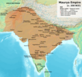
English: Note: This was the standard "textbook" map of the Maurya Empire. Historians are now arguing that the Maurya Empire did not include large parts of India, which were controlled by autonomous tribes. For such a map, see File:Maurya Empire, c.250 BCE.png.
Alternative map of Maurya Empire

Boundaries are based on Charles Joppen Historical Atlas of India (1907), see File:India_in_250_B._C.jpg.

Other Sources:

Other sources:

  • Grainger, John D. (1990, 2014). Seleukos Nikator: Constructing a Hellenistic Kingdom. Routledge.
  • Keay, John (2000). India, a History. New York: Harper Collins Publishers.
  • Kulke, H.; Rothermund, D. (2004). A History of India, 4th, Routledge.
  • Puri, Baji Nath (1996). Buddhism in Central Asia. Delhi: Motilal Banarsidass.
  • Raychaudhuri, H. C.; Mukherjee, B. N. (1996). Political History of Ancient India: From the Accession of Parikshit to the Extinction of the Gupta Dynasty. Oxford University Press.
  • Stein, Burton (1998). A History of India (1st ed.), Oxford: Wiley-Blackwell.

Notes:

  • Sri Lanka and the southernmost parts of India (modern Tamil Nadu and Kerala) remained independent, despite the diplomacy and cultural influence of their larger neighbor to the north (Schwartzberg 1992, p. 18; Kulke & Rothermund 2004, p. 68).
  • The account of Strabo indicates that the western-most territory of the empire extended from the southeastern Hindu Kush, through the region of Kandahar, to coastal Baluchistan south of that (Raychaudhuri & Mukherjee 1996, p. 594).
  • The claim that Aria/Herat was one of the provinces (alongside Arachosia, Gedrosia, and Paropamisadae) ceded by Seleucus to Chandragupta Maurya is often repeated, but Aria (modern Herat) "has been wrongly included in the list of ceded satrapies by some scholars [...] on the basis of wrong assessments of the passage of Strabo [...] and a statement by Pliny." (Raychaudhuri & Mukherjee 1996, p. 594). Seleucus "must [...] have held Aria", and furthermore, his "son Antiochos was active there fifteen years later." (Grainger 2014, p. 109).
  • "The region of Aria is definitely known to have been Seleucid under Seleucus I and Antiochus I as it definitely was after Antiochus III's great campaign in the east against the Parthians and Bactrians. [...] There is no evidence whatever that it did not remain Seleucid, like Drangiana, with which it is linked by easy routes." -Susan M. Sherwin-White and Amélie Kuhrt (1993) From Samarkhand to Sardis: A New Approach to the Seleucid Empire, University of California Press, pp.79-80.
  • It is recorded that Drangiana province continued to be in the Seleucids' hands, as per [1].
  • "Desert of Gedrosia [...] was left an unclaimed wilderness." —Kosmin, Paul J. (2014), The Land of the Elephant Kings Space, Territory, and Ideology in the Seleucid Empire, Harvard University Press, p.16
  • Schwartzberg (p. 18) speculates about the Buddhist culture and Kharosthi inscriptions/manuscripts found in Khotan, but these texts from Khotan, Turfan, and Tajikstan have all been shown to be later than the 1st century BCE (Puri, p. 185).
Dátum
Forrás A feltöltő saját munkája
Szerző Avantiputra7

Licenc

Én, e mű szerzője a művemet az alábbi licenc alatt teszem közzé:
w:hu:Creative Commons
Nevezd meg! Így add tovább!
Ez a fájl a Creative Commons Nevezd meg! – Így add tovább! 3.0 Unported licenc alapján használható fel.
A következőket teheted a művel:
  • megoszthatod – szabadon másolhatod, terjesztheted, bemutathatod és előadhatod a művet
  • feldolgozhatod – származékos műveket hozhatsz létre
Az alábbi feltételekkel:
  • Nevezd meg! – A szerzőt megfelelően fel kell tüntetned, hivatkozást kell létrehoznod a licencre és jelezned kell, ha a művön változtatást hajtottál végre. Ezt bármilyen észszerű módon megteheted, kivéve oly módon, ami azt sugallná hogy a jogosult támogat téged vagy a felhasználásod körülményeit.
  • Így add tovább! – Ha megváltoztatod, átalakítod, feldolgozod ezt a művet, a közreműködésedet csak az eredetivel megegyező vagy hasonló licenc alatt terjesztheted.

Képaláírások

Adj meg egy egysoros magyarázatot arról, hogy mit mutat be ez a fájl

A fájl által ábrázolt elemek

mű tárgya

3. július 2014

Fájltörténet

Kattints egy időpontra, hogy a fájl akkori állapotát láthasd.

(legutolsó | legelső) (10 újabb | ) (10 | 20 | 50 | 100 | 250 | 500)
Dátum/időBélyegképFelbontásFeltöltőMegjegyzés
aktuális2024. április 30., 13:01Bélyegkép a 2024. április 30., 13:01-kori változatról1 200 × 1 121 (2,26 MB)Avantiputra7western borders: see talk page
2024. április 16., 06:37Bélyegkép a 2024. április 16., 06:37-kori változatról1 200 × 1 121 (2,26 MB)Avantiputra7Reverted to version as of 11:12, 5 April 2024 (UTC) - vandalism
2024. április 14., 09:37Bélyegkép a 2024. április 14., 09:37-kori változatról1 200 × 1 121 (2,18 MB)Layman7676Reverted to version as of 11:12, 4 April 2024 (UTC) The map you are publishing isn't based on wha vincient Arthur really said.
2024. április 5., 13:12Bélyegkép a 2024. április 5., 13:12-kori változatról1 200 × 1 121 (2,26 MB)Avantiputra7Reverted to version as of 08:27, 3 April 2024 (UTC) - vandalism
2024. április 4., 13:12Bélyegkép a 2024. április 4., 13:12-kori változatról1 200 × 1 121 (2,18 MB)Chakravartin1929Reverted to version as of 05:41, 26 March 2024 (UTC) This is the true map. It depicts The mauryan map accurately.
2024. április 3., 10:27Bélyegkép a 2024. április 3., 10:27-kori változatról1 200 × 1 121 (2,26 MB)Avantiputra7Reverted to version as of 11:06, 3 March 2024 (UTC)
2024. március 26., 07:41Bélyegkép a 2024. március 26., 07:41-kori változatról1 200 × 1 121 (2,18 MB)Chakravartin1929Reverted to version as of 09:06, 3 March 2024 (UTC)
2024. március 3., 13:06Bélyegkép a 2024. március 3., 13:06-kori változatról1 200 × 1 121 (2,26 MB)Avantiputra7Reverted to version as of 11:10, 29 January 2024 (UTC)
2024. március 3., 11:06Bélyegkép a 2024. március 3., 11:06-kori változatról1 200 × 1 121 (2,18 MB)Chakravartin1929Reverted to version as of 16:50, 14 December 2023 (UTC) This map is better.
2024. január 29., 13:10Bélyegkép a 2024. január 29., 13:10-kori változatról1 200 × 1 121 (2,26 MB)Avantiputra7tweaked
(legutolsó | legelső) (10 újabb | ) (10 | 20 | 50 | 100 | 250 | 500)

Ezt a fájlt nem használja egyetlen lap sem.

Globális fájlhasználat

A következő wikik használják ezt a fájlt:

A fájl globális használatának megtekintése

Metaadatok