Eredeti fájl(1 741 × 1 243 képpont, fájlméret: 376 KB, MIME-típus: image/jpeg)

Összefoglaló

Leírás
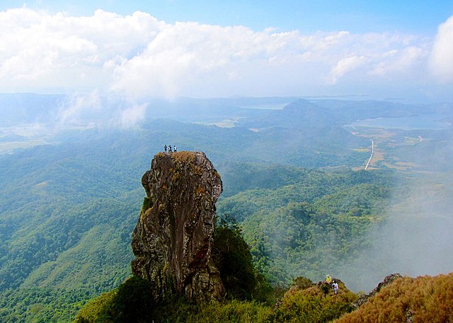
English: At the summit of Mt. Pico De Loro is a monolith. Also known as the Parrot's beak. It is a 60-meter natural rock formation often scaled by rock climbers. Shot by Schadow1 Expeditions during its mapping expedition to Pico De Loro of 2013.
Dátum
Forrás A feltöltő saját munkája
Szerző Ervin Malicdem
Engedély
(Fájl újrafelhasználása)
Én, e mű szerzője a művemet az alábbi licencek alatt teszem közzé:
GNU head Ez a fájl szabadon másolható, terjeszthető és/vagy módosítható a GNU Szabad Dokumentációs Licenc feltételei alapján, az 1.2 vagy későbbi, a Free Software Foundation által publikált Nem Változtatható szakaszok, Címlapszövegek és Hátlapszövegek nélküli változat szerint. E licenc egy példánya a GNU Szabad Dokumentációs Licenc című fejezetben olvasható.
w:hu:Creative Commons
Nevezd meg! Így add tovább!
Ez a fájl a Creative Commons Nevezd meg! – Így add tovább! 4.0 Nemzetközi licenc alapján használható fel.
A következőket teheted a művel:
  • megoszthatod – szabadon másolhatod, terjesztheted, bemutathatod és előadhatod a művet
  • feldolgozhatod – származékos műveket hozhatsz létre
Az alábbi feltételekkel:
  • Nevezd meg! – A szerzőt megfelelően fel kell tüntetned, hivatkozást kell létrehoznod a licencre és jelezned kell, ha a művön változtatást hajtottál végre. Ezt bármilyen észszerű módon megteheted, kivéve oly módon, ami azt sugallná hogy a jogosult támogat téged vagy a felhasználásod körülményeit.
  • Így add tovább! – Ha megváltoztatod, átalakítod, feldolgozod ezt a művet, a közreműködésedet csak az eredetivel megegyező vagy hasonló licenc alatt terjesztheted.
A mű a fenti licencek bármelyike szerint felhasználható.
Creative Commons Share-alike Attribution If you choose to use this work under the Creative Commons license stated above, the author, Ervin Malicdem (schadow1), would like you to attribute the work to him (among other requirements such as indicating that the work is licensed under the Creative Commons) with the following text or similar:
© Ervin Malicdem, 2013.

His name should be a link to his Wikimedia Commons userpage. If a link is not possible, then the url should be placed in parentheses after the name. If the work has been substantially altered by other people (see the File history section below), then this particular attribution requirement is waived, which means you can attribute the work in any reasonable manner.


This attribution requirement is provided pursuant to the Creative Commons Attribution-ShareAlike mechanism where "you must attribute the work in the manner specified by the author or licensor (but not in any way that suggests that they endorse you or your use of the work.) And if you remix the work, it must be distributed with the same license." (See "Attribution" in the Creative Commons website.)
Fényképező elhelyezkedése14° 12′ 51,27″ É, 120° 38′ 47,05″ K  Heading=201° Kartographer map based on OpenStreetMap.További képek erről a helyről: OpenStreetMapinfo

Initially published at Schadow1 Expeditions article available at http://www.s1expeditions.com/2013/01/pico-de-loro-summit-664masl-part-2.html

Képaláírások

Adj meg egy egysoros magyarázatot arról, hogy mit mutat be ez a fájl

A fájl által ábrázolt elemek

mű tárgya

5. január 2013

14°12'51.274800457"N, 120°38'47.047200000"E

heading angol: 201 fok

0,003125 másodperc

5 milliméter

ISO speed angol

200

Fájltörténet

Kattints egy időpontra, hogy a fájl akkori állapotát láthasd.

Dátum/időBélyegképFelbontásFeltöltőMegjegyzés
aktuális2015. január 17., 16:05Bélyegkép a 2015. január 17., 16:05-kori változatról1 741 × 1 243 (376 KB)Schadow1change to generic
2015. január 17., 14:46Bélyegkép a 2015. január 17., 14:46-kori változatról1 920 × 1 371 (487 KB)Schadow1User created page with UploadWizard

Az alábbi lap használja ezt a fájlt:

Globális fájlhasználat

A következő wikik használják ezt a fájlt:

Metaadatok