Fájl:NASA Worldwind, USGS imagery map, Jersey Island and Bethel Island, California.png

Az előnézet mérete: 800 × 472 képpont További felbontások: 320 × 189 képpont | 640 × 378 képpont | 856 × 505 képpont.
Eredeti fájl (856 × 505 képpont, fájlméret: 594 KB, MIME-típus: image/png)
|
Ez a fájl a Wikimedia Commonsból származik. Az alább látható leírás az ottani dokumentációjának másolata. A Commons projekt szabad licencű kép- és multimédiatár. Segíts te is az építésében! |
Összefoglaló
| Leírás |
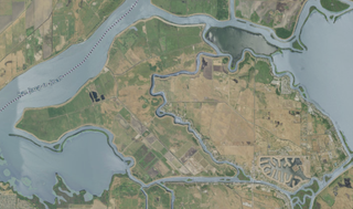
English: Satellite map of Jersey Island and Bethel Island, California |
|||
| Dátum | ||||
| Forrás | NASA tool at worldwind.earth, USGS Topo Imagery map layer | |||
| Szerző | Jacob Gotts | |||
| Engedély (Fájl újrafelhasználása) |
|
Fájltörténet
Kattints egy időpontra, hogy a fájl akkori állapotát láthasd.
| Dátum/idő | Bélyegkép | Felbontás | Feltöltő | Megjegyzés | |
|---|---|---|---|---|---|
| aktuális | 2020. szeptember 17., 08:25 | | 856 × 505 (594 KB) | JPxG | {{Information |description ={{en|1=Satellite map of Jersey Island and Bethel Island, California}} |date =2020-09-16 |source =NASA tool at worldwind.earth, USGS Topo Imagery map layer |author =Jacob Gotts |permission ={{PD-USGov-USGS}} }} Category:Islands of California |
Fájlhasználat
Az alábbi lap használja ezt a fájlt:
Globális fájlhasználat
A következő wikik használják ezt a fájlt:
- Használata itt: ceb.wikipedia.org
- Használata itt: en.wikipedia.org
- Használata itt: fr.wikipedia.org
- Használata itt: sr.wikipedia.org
- Használata itt: www.wikidata.org