Fájl:Persian Empire, 490 BC.png
Az előnézet mérete: 800 × 577 képpont További felbontások: 320 × 231 képpont | 640 × 461 képpont | 946 × 682 képpont.
Eredeti fájl (946 × 682 képpont, fájlméret: 159 KB, MIME-típus: image/png)
|
Ez a fájl a Wikimedia Commonsból származik. Az alább látható leírás az ottani dokumentációjának másolata. A Commons projekt szabad licencű kép- és multimédiatár. Segíts te is az építésében! |
Összefoglaló
| Leírás |
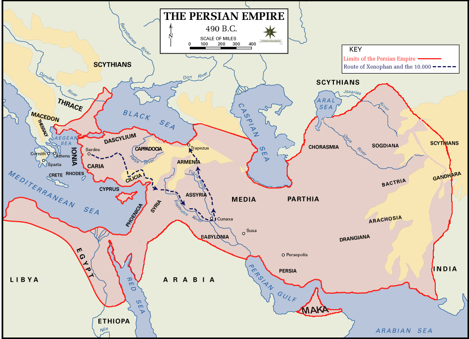
 English: Persian Empire, 490 BC, showing route of Cyrus the Younger, Xenophon and the 10.000.
Legends:
|
| Dátum | |
| Forrás | The Department of History - United States Military Academy |
| Szerző | DHUSMA |
| Engedély (Fájl újrafelhasználása) |
In the public domain as original works of the United States federal government and/or military |
| Más változatok | For a version of this image altered to display better in Wikipedia articles (converted to PNG format, slightly cropped in File:Persian Empire, 490 BC.gif) y Italian version. |

|
Ezt a képet el kellene készíteni vektorgrafika használatával SVG fájlként. A formátumnak számos előnye van; lásd a Commons:Media for cleanup lapot a további információkért. Ha a képnek már elérhető SVG-formátumú változata, töltsd fel. Az SVG feltöltése után cseréld le ezt a sablont a következőre: {{vector version available|új kép neve.svg}}.
|
Licenc
Ez a kép az az amerikai szövetségi kormány alkalmazottjának munkája, így a US Code 17. rész, 1 fejezetének, 105-ös szekciója alapján közkincsnek minősül . Lásd még: Szerzői jogok.
Megjegyzés: Ez kizárólag a szövetségi kormány képeire vonatkozik, nem pedig az egyes szövetségi államok, megyék, városok, vagy más közigazgatási egységek alkalmazottai által készített képekre.
|
 | |
| Megállapították, hogy ez a fájl mentes mindenféle szerzői jogi korlátozástól, beleértve az összes kapcsolódó és hozzátartozó jogot. | ||
Fájltörténet
Kattints egy időpontra, hogy a fájl akkori állapotát láthasd.
| Dátum/idő | Bélyegkép | Felbontás | Feltöltő | Megjegyzés | |
|---|---|---|---|---|---|
| aktuális | 2015. augusztus 2., 04:11 | | 946 × 682 (159 KB) | History of Persia | Achaemenid Arabia. see wikipedia article about achaemenid arabia |
| 2013. április 11., 13:21 |  | 942 × 684 (64 KB) | HistoryofIran | {{subst:Upload marker added by en.wp UW}} {{Information |Description = {{en|Added another region named Maka, it was listen on the Behistun inscription as part of the Achaemenid Empire.}} |Source = https://en.wikipedia.org/wiki/File:Persian_Empire,_490_... | |
| 2013. április 10., 21:21 |  | 942 × 684 (64 KB) | HistoryofIran | Changed where Chorasmia was written, it was much closer to the Aral sea. | |
| 2013. április 10., 21:19 |  | 942 × 684 (64 KB) | HistoryofIran | Added a more accurate map. | |
| 2012. december 8., 00:55 |  | 942 × 684 (64 KB) | Geagea | Colchis and Caucasian Iberia. Not Georgia. | |
| 2012. november 25., 18:24 |  | 942 × 684 (97 KB) | SilvioRusso | correction | |
| 2009. augusztus 27., 02:49 |  | 942 × 684 (64 KB) | AnonMoos | Version of File:Persian Empire, 490 BC.gif altered to display better in Wikipedia articles (converted to PNG format, slightly cropped). == Summary == ; Description : Persian Empire, 490 BC ; Author/Source : [http://www.dean.usma.edu/history/ The Depa |
Fájlhasználat
Ezt a fájlt nem használja egyetlen lap sem.
Globális fájlhasználat
A következő wikik használják ezt a fájlt:
- Használata itt: ast.wikipedia.org
- Használata itt: bg.wikipedia.org
- Használata itt: cs.wikipedia.org
- Használata itt: da.wikipedia.org
- Használata itt: el.wikipedia.org
- Használata itt: en.wikipedia.org
- Használata itt: fa.wikipedia.org
- Használata itt: fr.wikipedia.org
- Használata itt: fy.wikipedia.org
- Használata itt: hr.wikipedia.org
- Használata itt: hy.wikipedia.org
- Használata itt: id.wikipedia.org
- Használata itt: it.wikipedia.org
- Használata itt: ko.wikipedia.org
- Használata itt: ku.wikipedia.org
- Használata itt: la.wikipedia.org
- Használata itt: nl.wikipedia.org
- Használata itt: no.wikipedia.org
- Használata itt: pnb.wikipedia.org
- Használata itt: pnt.wikipedia.org
- Használata itt: ro.wikipedia.org
- Használata itt: ru.wikipedia.org
- Használata itt: sh.wikipedia.org
- Használata itt: sr.wikipedia.org
- Használata itt: sv.wikipedia.org
- Használata itt: tg.wikipedia.org
- Használata itt: tr.wikipedia.org
A fájl globális használatának megtekintése