Fájl:PointeDuHoc.png

Eredeti fájl (3 200 × 2 400 képpont, fájlméret: 276 KB, MIME-típus: image/png)
|
Ez a fájl a Wikimedia Commonsból származik. Az alább látható leírás az ottani dokumentációjának másolata. A Commons projekt szabad licencű kép- és multimédiatár. Segíts te is az építésében! |
Összefoglaló
| Leírás |
|
||
| Dátum | |||
| Forrás | A feltöltő saját munkája | ||
| Alkotó | |||
| Származás | © Tom Fish, geo.fish // Creative Commons BY-SA 4.0 | ||
| Engedély (Fájl újrafelhasználása) |
|
||
| Georeferencing | If inappropriate please set warp_status = skip to hide. | ||
| PNG kód | Ez PNG számítógépes grafika ArcGIS Pro segítségével készült |
Licenc
Data
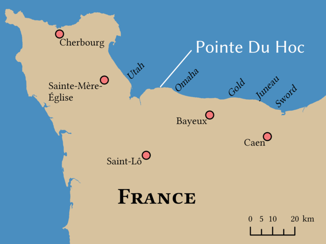
Land
The land layer was sourced from the Large Scale International Boundaries published by the US Department of State
| This image is a work of a United States Department of State employee, taken or made as part of that person's official duties. As a work of the U.S. federal government, the image is in the public domain per 17 U.S.C. § 101 and § 105 and the Department Copyright Information. |  |
Locations
the locations of cities in France, Landing Zones, and Pointe du Hoc are facts and are not eligible for copyright protection. While other sources were used to verify the locations, they were placed by hand and are not derived from a GIS layer
| Ez a kép közkincs, mert nincs egyéni-eredeti jellege. |
Final Map
- A következőket teheted a művel:
- megoszthatod – szabadon másolhatod, terjesztheted, bemutathatod és előadhatod a művet
- feldolgozhatod – származékos műveket hozhatsz létre
- Az alábbi feltételekkel:
- Nevezd meg! – A szerzőt megfelelően fel kell tüntetned, hivatkozást kell létrehoznod a licencre és jelezned kell, ha a művön változtatást hajtottál végre. Ezt bármilyen észszerű módon megteheted, kivéve oly módon, ami azt sugallná hogy a jogosult támogat téged vagy a felhasználásod körülményeit.
- Így add tovább! – Ha megváltoztatod, átalakítod, feldolgozod ezt a művet, a közreműködésedet csak az eredetivel megegyező vagy hasonló licenc alatt terjesztheted.
Fájltörténet
Kattints egy időpontra, hogy a fájl akkori állapotát láthasd.
| Dátum/idő | Bélyegkép | Felbontás | Feltöltő | Megjegyzés | |
|---|---|---|---|---|---|
| aktuális | 2021. november 10., 16:27 | | 3 200 × 2 400 (276 KB) | Guerillero | Increase size of Pointe Du Hoc label |
| 2021. november 10., 16:23 |  | 3 200 × 2 400 (284 KB) | Guerillero | {{User:Guerillero/Template |Description= {{en|The location of Pointe du Hoc}} |Source={{own}} |Date= 10 November 2021 }} == {{int:license-header}} == ===Data=== ====Land==== The land layer was sourced from the Large Scale International Boundaries published by the US Department of State {{PD-USGov-DOS}} ====Locations==== the locations of cities in France, Landing Zones, and Pointe du Hoc are facts and are not eligible for copyright protection.... |
Fájlhasználat
Az alábbi lap használja ezt a fájlt:
Globális fájlhasználat
A következő wikik használják ezt a fájlt:
- Használata itt: cs.wikipedia.org
- Használata itt: da.wikipedia.org
- Használata itt: en.wikipedia.org