Fájl:Roman provinces trajan.svg

Ennek a(z) SVG fájlnak ezen PNG formátumú előnézete: 800 × 457 képpont. További felbontások: 320 × 183 képpont | 640 × 366 képpont | 1 024 × 585 képpont | 1 280 × 732 képpont | 2 560 × 1 463 képpont | 1 732 × 990 képpont.
Eredeti fájl (SVG fájl, névlegesen 1 732 × 990 képpont, fájlméret: 757 KB)
|
Ez a fájl a Wikimedia Commonsból származik. Az alább látható leírás az ottani dokumentációjának másolata. A Commons projekt szabad licencű kép- és multimédiatár. Segíts te is az építésében! |
Összefoglaló
| Leírás |
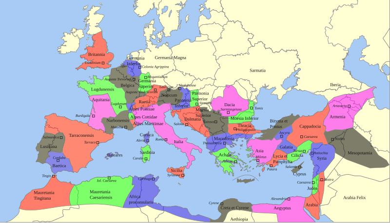
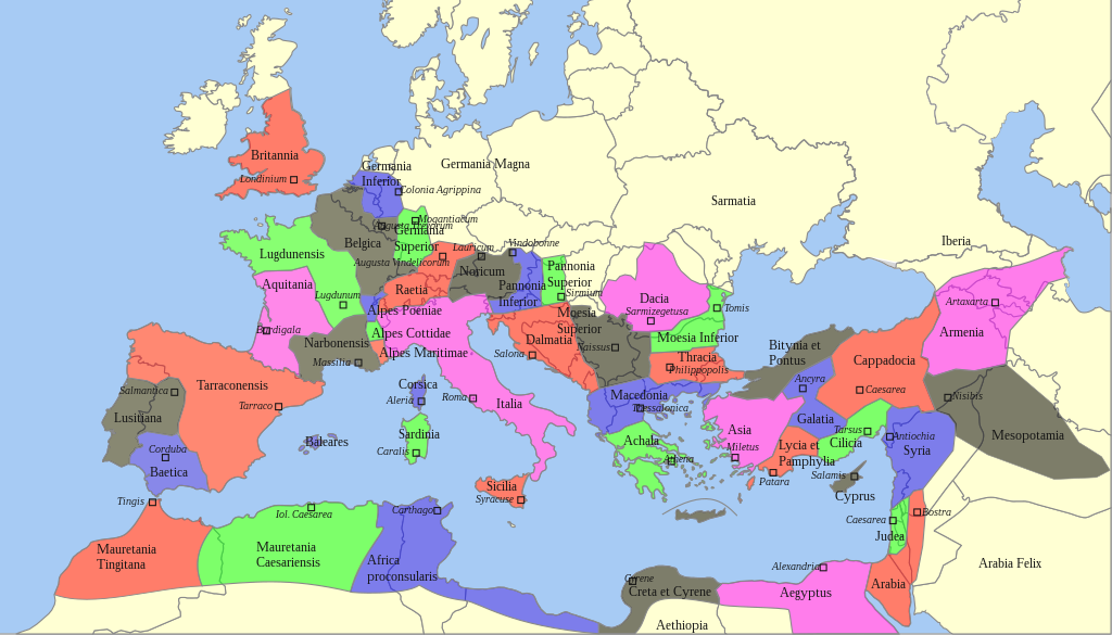
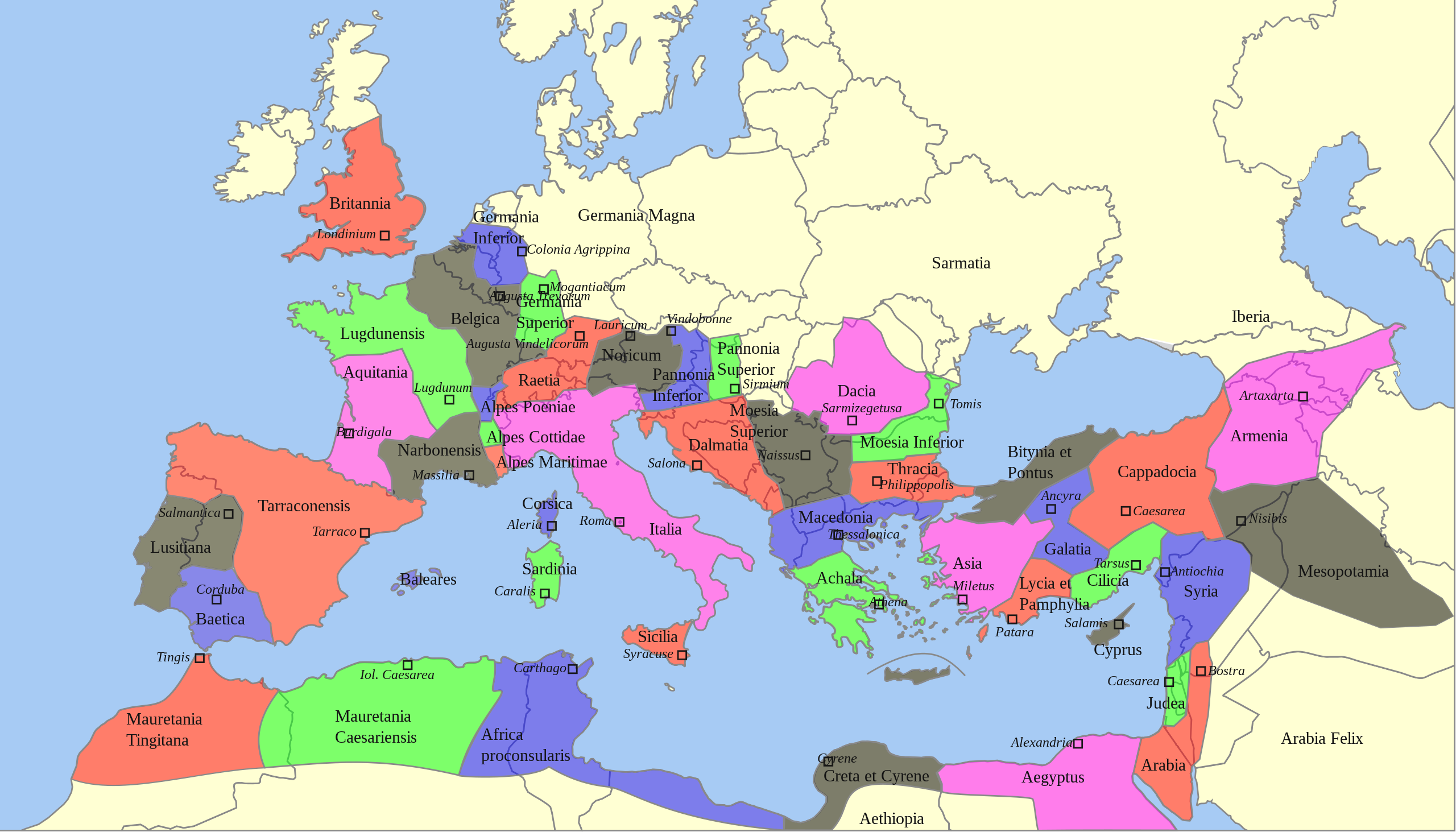
Deutsch: Territoriale Ausdehnung und provinziale Aufteilung des Römischen Reichs unter Trajan (117 n. Chr.) auf einer politischen Karte von 2013
English: Territorial extension and provincial division of the Roman Empire under Trajan (117 AD) on a political map of 2013 |
| Dátum | |
| Forrás |
Ez a fájl ebből származik: |
| Szerző |
|
| SVG kód | Ez vektorgrafikus kép CorelDRAW segítségével készült |
Licenc
Sebastian Wallroth, e mű szerzője a művét az alábbi licenc alatt teszi közzé:
| Én, a szerző, ezt a művemet ezennel közkinccsé nyilvánítom. Ez a világ minden részén érvényes. Egyes országokban ez jogilag nem lehetséges. Ha így van, akkor: Jogot adok bárkinek, hogy bármilyen célból, feltétel nélkül használhassa ezt a fájlt, kivéve a törvény által kötelezően előírt feltételeket. |
Eredeti feltöltési napló
This image is a derivative work of the following images:
- Roemischeprovinzentrajan.png licensed with PD-Demis
- 2007-06-29T05:49:35Z ThomasPusch 1218x730 (314106 Bytes) Name of "Mauretania Caesariensis'' (one "s" was missing) corrected - Name von "Mauretania Caesariensis" berichtigt - nomo de "Mauretania Caesariensis'' korektita
- 2005-11-27T11:10:02Z FJ-de 1218x730 (339534 Bytes) Karte ist erstellt von mir - Vorlage Demis http://www.demis.nl/wms/mapclip.htm
- Blank Map of Europe -w boundaries.svg licensed with Cc-by-sa-2.5,2.0,1.0, Cc-by-sa-3.0-migrated, GFDL
- 2008-06-19T01:33:53Z Roke 2045x1720 (724499 Bytes) more accurate version derived from [[:Image:Location European nation states.svg]] using same colours
- 2006-09-25T23:00:04Z Madman2001 0x0 (224972 Bytes) A blank map of Europe using Wikipedia standard colors in SVG format, based on [[:Image:BlankMap-Europe-v5.png]]. Note that the borders represent a second object "grouped" with the outline of Europe.
Uploaded with derivativeFX
Fájltörténet
Kattints egy időpontra, hogy a fájl akkori állapotát láthasd.
| Dátum/idő | Bélyegkép | Felbontás | Feltöltő | Megjegyzés | |
|---|---|---|---|---|---|
| aktuális | 2022. február 22., 08:59 | | 1 732 × 990 (757 KB) | Chaddy | Reverted to version as of 08:05, 17 May 2013 (UTC) this map is heavily broken since September |
| 2021. szeptember 24., 19:00 |  | 1 732 × 990 (576 KB) | Sebastian Wallroth | invalid element removed // Editing SVG source code using c:User:Rillke/SVGedit.js | |
| 2021. szeptember 24., 18:55 |  | 1 732 × 990 (576 KB) | Sebastian Wallroth | justified // Editing SVG source code using c:User:Rillke/SVGedit.js | |
| 2021. szeptember 24., 18:52 |  | 1 732 × 990 (577 KB) | Sebastian Wallroth | edited // Editing SVG source code using c:User:Rillke/SVGedit.js | |
| 2021. szeptember 24., 18:48 |  | 1 732 × 990 (579 KB) | Sebastian Wallroth | code reviewed // Editing SVG source code using c:User:Rillke/SVGedit.js | |
| 2013. május 17., 10:05 |  | 1 732 × 990 (757 KB) | Sebastian Wallroth | pure SVG | |
| 2013. május 17., 09:51 |  | 1 732 × 990 (756 KB) | Sebastian Wallroth | cut out | |
| 2013. május 17., 09:49 |  | 2 043 × 982 (679 KB) | Sebastian Wallroth | == {{int:filedesc}} == {{Information |Description={{de|Territoriale Ausdehnung und provinziale Aufteilung des Römischen Reichs unter Trajan (117 n. Chr.) auf einer politischen Karte von 2013}} {{en|Territorial extension and provincial division of the ... |
Fájlhasználat
Ezt a fájlt nem használja egyetlen lap sem.
Globális fájlhasználat
A következő wikik használják ezt a fájlt:
- Használata itt: en.wikipedia.org
- Használata itt: es.wikibooks.org
- Használata itt: sk.wikipedia.org