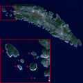
Fájl:Solta satelite annotated.png

Az előnézet mérete: 600 × 600 képpont További felbontások: 240 × 240 képpont | 480 × 480 képpont | 750 × 750 képpont.
Eredeti fájl (750 × 750 képpont, fájlméret: 534 KB, MIME-típus: image/png)
Fájltörténet
Kattints egy időpontra, hogy a fájl akkori állapotát láthasd.
| Dátum/idő | Bélyegkép | Felbontás | Feltöltő | Megjegyzés | |
|---|---|---|---|---|---|
| aktuális | 2009. október 17., 14:56 |  | 750 × 750 (534 KB) | Žedno | {{Information |Description=Annotated satelite image of island Šolta and group of small islands on the west. |Source=*File:Solta_satelite.jpg |Date=2009-10-17 12:55 (UTC) |Author=*File:Solta_satelite.jpg: user:Dijxtra *deriva |
Fájlhasználat
Az alábbi lapok használják ezt a fájlt:
Globális fájlhasználat
A következő wikik használják ezt a fájlt:
- Használata itt: ceb.wikipedia.org
- Használata itt: hr.wikipedia.org
- Használata itt: it.wikipedia.org
- Használata itt: pl.wikipedia.org
- Használata itt: www.wikidata.org
