Fájl:Tetiaroa.jpg
Eredeti fájl (617 × 668 képpont, fájlméret: 111 KB, MIME-típus: image/jpeg)
|
Ez a fájl a Wikimedia Commonsból származik. Az alább látható leírás az ottani dokumentációjának másolata. A Commons projekt szabad licencű kép- és multimédiatár. Segíts te is az építésében! |
Összefoglaló
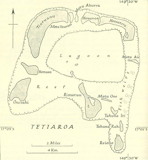
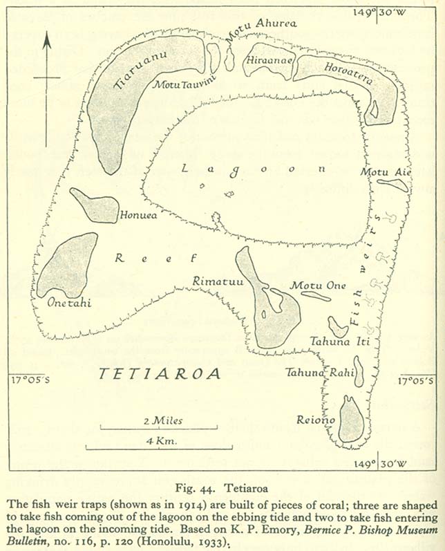
http://www.lib.utexas.edu/maps/historical/pacific_islands_1943_1945/tetiaroa.jpg
Public domain, as explained on page http://www.lib.utexas.edu/usage_statement.html?maps=yes: "Most of the maps scanned by the University of Texas Libraries and served from this web site are in the public domain. No permissions are needed to copy them. You may download them and use them as you wish. A few maps are copyrighted, and are clearly marked as such."
The motu of Tahuna Iti and the sandbank of Motu One are interchanged on the map.
Licenc
This file is in the public domain because it has been taken from a collection of public domain maps at the University of Texas Library
|
Fájltörténet
Kattints egy időpontra, hogy a fájl akkori állapotát láthasd.
| Dátum/idő | Bélyegkép | Felbontás | Feltöltő | Megjegyzés | |
|---|---|---|---|---|---|
| aktuális | 2014. január 18., 10:00 | | 617 × 668 (111 KB) | Cropbot | upload cropped version, operated by User:Andy king50. Summary: cropped |
| 2006. október 21., 17:23 |  | 644 × 797 (92 KB) | Ratzer | http://www.lib.utexas.edu/maps/historical/pacific_islands_1943_1945/tetiaroa.jpg Public domain, as explained on page http://www.lib.utexas.edu/usage_statement.html?maps=yes: "Most of the maps scanned by the University of Texas Libraries and served from t |
Fájlhasználat
Az alábbi lap használja ezt a fájlt:
Globális fájlhasználat
A következő wikik használják ezt a fájlt:
- Használata itt: als.wikipedia.org
- Használata itt: az.wikipedia.org
- Használata itt: ca.wikipedia.org
- Használata itt: de.wikipedia.org
- Használata itt: en.wikipedia.org
- Használata itt: eo.wikipedia.org
- Használata itt: es.wikipedia.org
- Használata itt: fr.wikipedia.org
- Használata itt: gl.wikipedia.org
- Használata itt: mk.wikipedia.org
- Használata itt: no.wikipedia.org
- Használata itt: pl.wikipedia.org
- Használata itt: pt.wikipedia.org
- Használata itt: ru.wikipedia.org
- Használata itt: sv.wikipedia.org
- Használata itt: zh.wikipedia.org