Fájl:U-Bahn Wien, Netzplan.svg

Ennek a(z) SVG fájlnak ezen PNG formátumú előnézete: 637 × 600 képpont. További felbontások: 255 × 240 képpont | 510 × 480 képpont | 816 × 768 képpont | 1 088 × 1 024 képpont | 2 176 × 2 048 képpont | 835 × 786 képpont.
Eredeti fájl (SVG fájl, névlegesen 835 × 786 képpont, fájlméret: 152 KB)
|
Ez a fájl a Wikimedia Commonsból származik. Az alább látható leírás az ottani dokumentációjának másolata. A Commons projekt szabad licencű kép- és multimédiatár. Segíts te is az építésében! |
Összefoglaló
| Leírás |
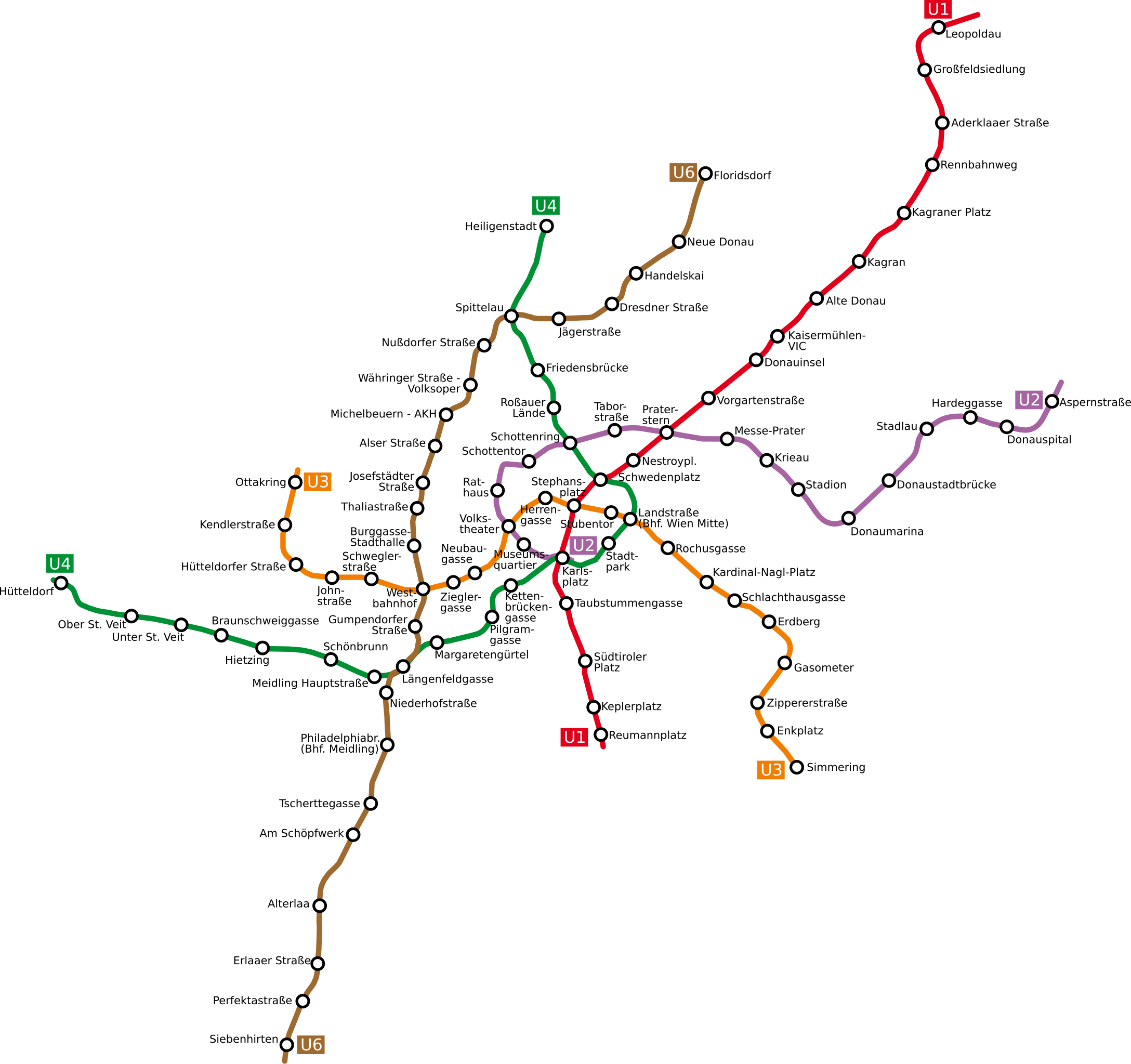
Deutsch: Netzplan der Wiener U-Bahn
English: The underground network of the Austrian capital Vienna
Esperanto: La metroreto de la Aŭstruja ĉefurbo Vieno
Polski: Plan wiedeńskiego metra |
| Dátum | |
| Forrás | http://www.openstreetmap.org/browse/relation/27116 |
| Szerző | OpenStreetMap contributors, Ircecho |
| SVG kód | Ezen SVG kép forráskódja érvénytelen. Ez vektorgrafikus kép Inkscape segítségével készült, or with something else. |
Licenc
Én, e mű szerzője a művemet az alábbi licenc alatt teszem közzé:
Ez a fájl a Creative Commons Nevezd meg! – Így add tovább! 2.0 Generic licenc alapján használható fel.
- A következőket teheted a művel:
- megoszthatod – szabadon másolhatod, terjesztheted, bemutathatod és előadhatod a művet
- feldolgozhatod – származékos műveket hozhatsz létre
- Az alábbi feltételekkel:
- Nevezd meg! – A szerzőt megfelelően fel kell tüntetned, hivatkozást kell létrehoznod a licencre és jelezned kell, ha a művön változtatást hajtottál végre. Ezt bármilyen észszerű módon megteheted, kivéve oly módon, ami azt sugallná hogy a jogosult támogat téged vagy a felhasználásod körülményeit.
- Így add tovább! – Ha megváltoztatod, átalakítod, feldolgozod ezt a művet, a közreműködésedet csak az eredetivel megegyező vagy hasonló licenc alatt terjesztheted.
Fájltörténet
Kattints egy időpontra, hogy a fájl akkori állapotát láthasd.
| Dátum/idő | Bélyegkép | Felbontás | Feltöltő | Megjegyzés | |
|---|---|---|---|---|---|
| aktuális | 2011. április 12., 17:07 | | 835 × 786 (152 KB) | Ircecho | I now improved readability. Additionally i removed the city border as to make the update just an update. As based on my research i think the old plan is incorrect, its in my opinion right to overwrite it with this redo. |
| 2011. április 8., 16:30 |  | 1 063 × 1 020 (136 KB) | Invisigoth67 | Reverted to version as of 18:54, 30 March 2011: Please do not overwrite with a complete new plan, use an new filename instead. This version is much better readable than the new layout. | |
| 2011. április 4., 20:28 |  | 1 488 × 1 052 (271 KB) | Ircecho | Redid the whole plan. | |
| 2011. március 30., 20:54 |  | 1 063 × 1 020 (136 KB) | Ircecho | Extended the map to include the expansion state of 2011. Track and station positions are based on openstreetmap data, which was aligned to stations Donauinsel, Vorgartenstrasse, Krieau, Kardinal-Nagl-Platz and Schlachthausgasse. Stadion was moved a bit, f | |
| 2008. május 11., 19:44 |  | 982 × 1 031 (132 KB) | Aldaron | == Summary == {{Information |Description=*de: Netzplan der Wiener U-Bahn *en: The underground network of the Austrian capital Vienna |Source= |Date=2007 |Author=Based on original upload by L.m.k |Permission= |other_versions= }} | |
| 2007. március 13., 13:19 |  | 982 × 1 031 (127 KB) | Hukkepakk | == Summary == {{Information |Description=*[:de:]] Netzplan der Wiener U-Bahn *en: The underground network of the Austrian capital Vienna.}} |Source= |Date=2007 |Author=L.m.k |Permission= |other_versions= }} == Licensing == {{self2|GFD |
Fájlhasználat
Ezt a fájlt nem használja egyetlen lap sem.
Globális fájlhasználat
A következő wikik használják ezt a fájlt:
- Használata itt: ca.wikipedia.org
- Használata itt: da.wikipedia.org
- Használata itt: de.wikipedia.org
- Használata itt: eo.wikipedia.org
- Használata itt: ro.wikipedia.org
- Használata itt: ru.wikivoyage.org
- Használata itt: sk.wikipedia.org