Fájl:USACE Englebright Dam and Lake.jpg

Az előnézet mérete: 800 × 526 képpont További felbontások: 320 × 211 képpont | 640 × 421 képpont | 1 024 × 674 képpont | 1 500 × 987 képpont.
Eredeti fájl (1 500 × 987 képpont, fájlméret: 638 KB, MIME-típus: image/jpeg)
|
Ez a fájl a Wikimedia Commonsból származik. Az alább látható leírás az ottani dokumentációjának másolata. A Commons projekt szabad licencű kép- és multimédiatár. Segíts te is az építésében! |
| Leírás |
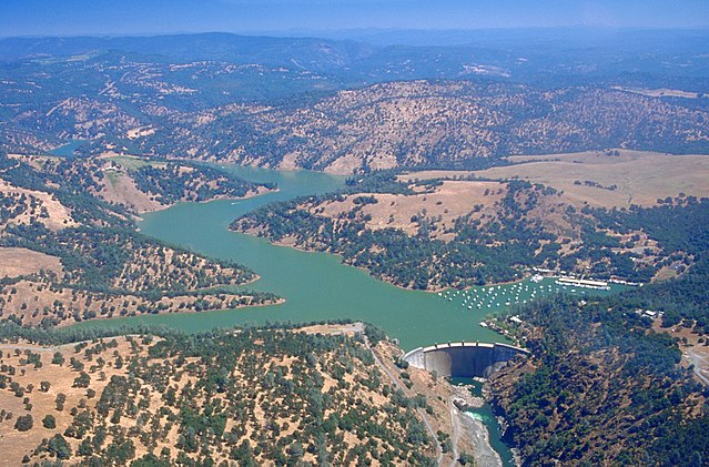
English: Englebright Dam and Lake on the Yuba River in the state of California, USA. The dam is located approximately 20 miles (32 km) east-northeast of Yuba City, California. The river and dam span the border between Yuba County and Nevada Counties. The dam was constructed in 1941 by the U.S. Army Corps of Engineers for flood control on the Yuba River.
Coordinates: 39°14′23.81″N 121°16′10.02″W / 39.2399472°N 121.26945°W |
|||
| Helyszín | Yuba and Nevada Counties, California, USA | |||
| Dátum | not specified or unknown | |||
| Forrás |
U.S. Army Corps of Engineers Digital Visual Library Image page Image description page Digital Visual Library home page |
|||
| Szerző | Michael Nevins, U.S. Army Corps of Engineers | |||
| Engedély (Fájl újrafelhasználása) |
|
Fájltörténet
Kattints egy időpontra, hogy a fájl akkori állapotát láthasd.
| Dátum/idő | Bélyegkép | Felbontás | Feltöltő | Megjegyzés | |
|---|---|---|---|---|---|
| aktuális | 2007. május 5., 17:27 | | 1 500 × 987 (638 KB) | DanMS | {{Information | Description = {{en|Englebright Dam and Lake on the Yuba River in the state of California, USA. The dam is located approximately 20 miles (32 km) east-northeast of Yuba City, California. The river and dam span the border between Yuba Cou |
Fájlhasználat
Az alábbi lapok használják ezt a fájlt:
Globális fájlhasználat
A következő wikik használják ezt a fájlt:
- Használata itt: ar.wikipedia.org
- Használata itt: az.wikipedia.org
- Használata itt: ceb.wikipedia.org
- Használata itt: ce.wikipedia.org
- Használata itt: cs.wikipedia.org
- Használata itt: cy.wikipedia.org
- Használata itt: en.wikipedia.org
- Használata itt: en.wikivoyage.org
- Használata itt: eo.wikipedia.org
- Használata itt: es.wikipedia.org
- Használata itt: ga.wikipedia.org
- Használata itt: hy.wikipedia.org
- Használata itt: no.wikipedia.org
- Használata itt: pl.wikipedia.org
- Használata itt: pt.wikipedia.org
- Használata itt: ru.wikipedia.org
- Használata itt: sr.wikipedia.org
- Használata itt: tr.wikipedia.org
- Használata itt: tt.wikipedia.org
- Használata itt: www.wikidata.org