Fájl:Völkerkarte von Mittel- und Südosteuropa. Italien 1815 bis zur Gegenwart (1905).jpg

Eredeti fájl (1 574 × 1 886 képpont, fájlméret: 600 KB, MIME-típus: image/jpeg)
|
Ez a fájl a Wikimedia Commonsból származik. Az alább látható leírás az ottani dokumentációjának másolata. A Commons projekt szabad licencű kép- és multimédiatár. Segíts te is az építésében! |
.jpg)
Összefoglaló
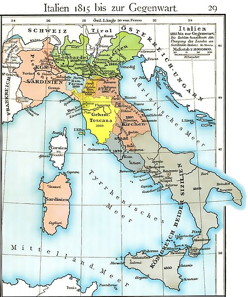
| Leírás | Cartina dell'unificazione d'Italia dal 1815 fino al 1870 (il ducato di Massa e Carrara, ufficialmente indipendente fino al 1829, non è però indicato, e, non correttamente, è già considerato parte del ducato di Modena fin dal 1815) |
| Dátum | |
| Forrás | Historischer Schulatlas di F. W Putzger (1814--1913) Plate 29 from F. W. Putzgers Historischer Schul-Atlas |
| Szerző | F. W Putzger (1814--1913) |
| Más változatok | File:Italy unification 1815 1870.jpg |
derivative works
Származékos művek: Italy1816cs.png Putzger, Historischer Schul-Atlas di F. W Putzger (1814--1913).
Licenc
|
Ez a mű közkincs abban az országban, ahol elkészítették, és minden olyan további államban, ahol a szerzői jogi védelmi idő a szerző élete plusz 70 év vagy kevesebb.
| |
| Megállapították, hogy ez a fájl mentes mindenféle szerzői jogi korlátozástól, beleértve az összes kapcsolódó és hozzátartozó jogot. | |
Fájltörténet
Kattints egy időpontra, hogy a fájl akkori állapotát láthasd.
| Dátum/idő | Bélyegkép | Felbontás | Feltöltő | Megjegyzés | |
|---|---|---|---|---|---|
| aktuális | 2011. március 19., 14:40 | | 1 574 × 1 886 (600 KB) | A7N8X | cleared from the watermark image, improved compression. jpeg, making it progressively improving and quick viewing |
| 2009. január 22., 17:33 |  | 1 640 × 1 971 (1 007 KB) | MegaMatic | {{PD-old}} | |
| 2006. május 23., 13:34 |  | 1 640 × 1 971 (1,05 MB) | Massimo Macconi | Cartina dell'Italia nel 1815 tratta da Historisches Schulatlas di F. W Putzgers (1814--1913) |
Fájlhasználat
Az alábbi lapok használják ezt a fájlt:
Globális fájlhasználat
A következő wikik használják ezt a fájlt:
- Használata itt: af.wikipedia.org
- Használata itt: als.wikipedia.org
- Használata itt: ast.wikipedia.org
- Használata itt: br.wikipedia.org
- Használata itt: ca.wikipedia.org
- Használata itt: de.wikipedia.org
- Használata itt: en.wikipedia.org
- Használata itt: fr.wikipedia.org
- Használata itt: it.wikipedia.org
- Használata itt: la.wikipedia.org
- Használata itt: nl.wikipedia.org
- Használata itt: pl.wikipedia.org
- Használata itt: scn.wikipedia.org
- Használata itt: sk.wikipedia.org
- Használata itt: vec.wikipedia.org
- Használata itt: www.wikidata.org
.jpg)