Fájl:Gettysburg Day2 Wheatfield1.png
Az előnézet mérete: 800 × 600 képpont További felbontások: 320 × 240 képpont | 640 × 480 képpont | 1 024 × 768 képpont | 1 280 × 960 képpont | 2 560 × 1 920 képpont | 4 800 × 3 600 képpont.
Eredeti fájl (4 800 × 3 600 képpont, fájlméret: 9,56 MB, MIME-típus: image/png)
|
Ez a fájl a Wikimedia Commonsból származik. Az alább látható leírás az ottani dokumentációjának másolata. A Commons projekt szabad licencű kép- és multimédiatár. Segíts te is az építésében! |
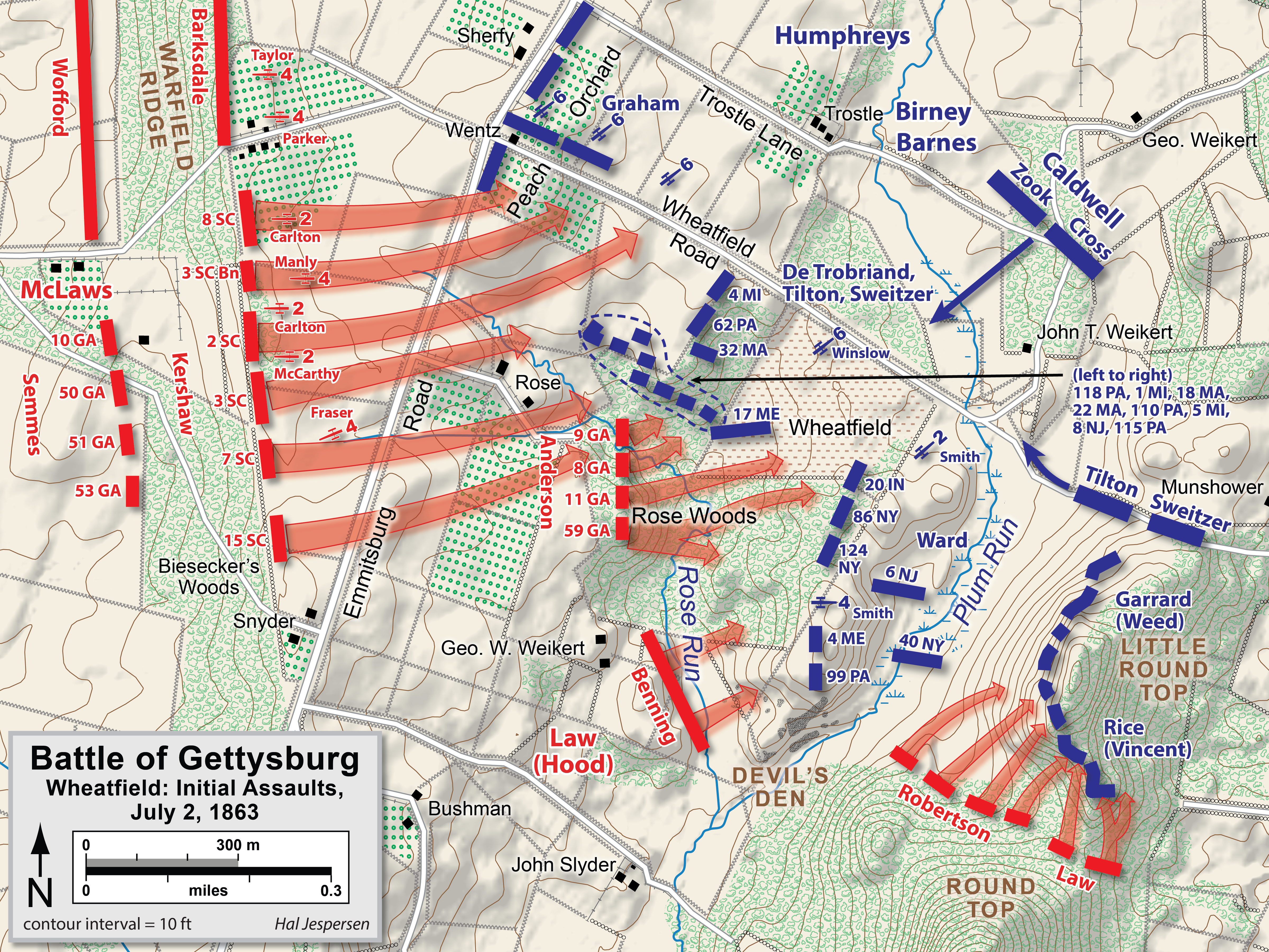
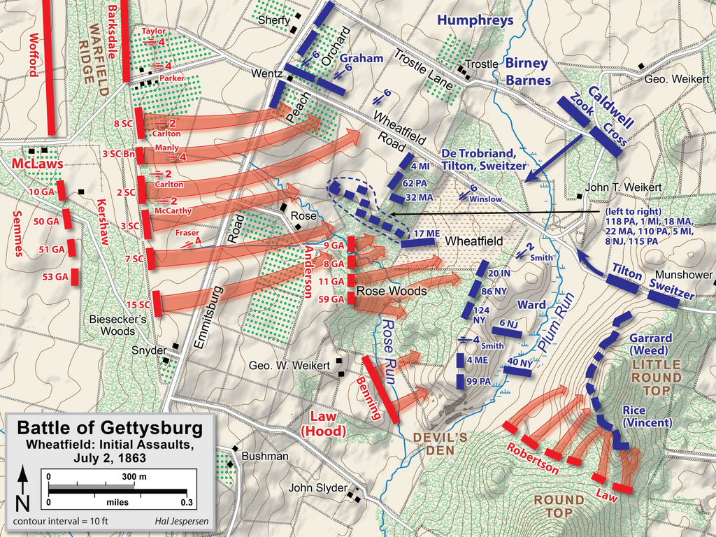
| Leírás | Map of Wheatfield actions in the Battle of Gettysburg, Second Day, of the American Civil War. Updated unit positions and made topographical background consistent with many other Wikipedia Gettysburg maps. Drawn in Adobe Illustrator CS5 by Hal Jespersen. Graphic source file is available at http://www.posix.com/CWmaps/ |
| Dátum | |
| Forrás | A feltöltő saját munkája |
| Szerző | Hal Jespersen |
Ez a fájl a Creative Commons Nevezd meg! 3.0 Unported licenc alapján használható fel.
Így nevezd meg: Map by Hal Jespersen, www.posix.com/CW
- A következőket teheted a művel:
- megoszthatod – szabadon másolhatod, terjesztheted, bemutathatod és előadhatod a művet
- feldolgozhatod – származékos műveket hozhatsz létre
- Az alábbi feltételekkel:
- Nevezd meg! – A szerzőt megfelelően fel kell tüntetned, hivatkozást kell létrehoznod a licencre és jelezned kell, ha a művön változtatást hajtottál végre. Ezt bármilyen észszerű módon megteheted, kivéve oly módon, ami azt sugallná hogy a jogosult támogat téged vagy a felhasználásod körülményeit.
Fájltörténet
Kattints egy időpontra, hogy a fájl akkori állapotát láthasd.
| Dátum/idő | Bélyegkép | Felbontás | Feltöltő | Megjegyzés | |
|---|---|---|---|---|---|
| aktuális | 2023. február 3., 19:39 | | 4 800 × 3 600 (9,56 MB) | Hlj | improved graphics and detail |
| 2011. április 2., 22:03 |  | 2 449 × 1 789 (1,21 MB) | Hlj | Updated graphical format of rivers and roads. Same license. | |
| 2010. július 31., 02:04 |  | 2 449 × 1 789 (1,17 MB) | Hlj | New version improves accuracy of unit positions and graphic style that matches others in the Gettysburg series. Added legend box. Drawn by Hal Jespersen in Adobe Illustrator CS5. Graphic source file is available at http://www.posix.com/CWmaps/ {{cc-by-3.0 | |
| 2010. július 10., 20:33 |  | 2 449 × 1 789 (1,17 MB) | Hlj | {{Information |Description=Map of Little Round Top (Battle of Gettysburg) of the American Civil War. Updated unit positions and made topographical background consistent with many other Wikipedia Gettysburg maps. Drawn in Adobe Illustrator CS5 by Hal J | |
| 2006. november 16., 16:15 |  | 1 483 × 1 203 (510 KB) | Rheo1905~commonswiki | This map is made by en:User:Hlj. 1863. 7. 2. Gettysburg Second Day, Battle of Wheatfield (1) {{PD-release}} |
Fájlhasználat
Az alábbi lapok használják ezt a fájlt:
Globális fájlhasználat
A következő wikik használják ezt a fájlt:
- Használata itt: cs.wikipedia.org
- Használata itt: da.wikipedia.org
- Használata itt: en.wikipedia.org
- Használata itt: ko.wikipedia.org
- Használata itt: ru.wikipedia.org
- Használata itt: zh.wikipedia.org